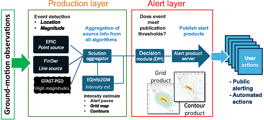
Schematic view of the USGS-operated ShakeAlert system1 processing algorithms. Seismic and geodetic ground‐motion observations are processed and then fed into three algorithms (EPIC, FinDer, and GFAST‐peak ground displacement [PGD]) to estimate source parameters. Those parameters are combined in the solution aggregator (SA) and fed to the eqInfo2GM algorithm to produce the grid (the terms grid product and map product are used interchangeably) and contour products that estimate ground motions. Finally, the decision module (DM) checks to see if the alert meets publication thresholds and, if so, it publishes ShakeAlert Messages2 with the event, contour, and map products to the alert servers. Licensed operators connect to the ShakeAlert Message (Alert) Servers and subscribe to ShakeAlert Messages topics to receive these data products. Reference: Given et al. (2018)
Earthquake Point‐source Integrated Code (EPIC): The EPIC algorithm is a point-source algorithm that uses P-wave data to detect an earthquake and estimate its source parameters (magnitude, epicenter, and origin time). To detect an earthquake, EPIC requires P-wave triggers from at least four stations and for 40% of nearby stations to have triggered. EPIC estimates the magnitude of the earthquake with a scaling relationship that uses peak displacement (Pd) observations. EPIC uses a minimum of 0.5 sec of data from each station, and a maximum of ~4 sec of data (sometimes slightly more due to 1 sec packet lengths). Magnitude estimates are computed at each station individually and then combined using a weighted average according to the amount of data available at each station. These source estimates are updated as more data arrive. Because EPIC uses P-wave data, it is typically the fastest and most sensitive of the EEW algorithms in the ShakeAlert system.
Finite-Fault Detector (FinDer): The FinDer algorithm uses peak ground acceleration (PGA) data to detect an earthquake and estimate its source parameters. To detect an earthquake, FinDer requires at least four stations to exceed a PGA trigger threshold of 2 cm/s2 and for these stations to be spatially connected to each other (i.e., neighbors). FinDer estimates the earthquake’s magnitude by matching the observed PGA distribution with pre-computed PGA distribution templates, where the best-fitting template indicates the earthquake’s magnitude as well as the length and orientation of the fault rupture, which are helpful source information for determining ground-motion distributions for larger-magnitude earthquakes. FinDer can only alert alone if it estimates an earthquake magnitude is M5.5+. For earthquakes with magnitude estimates of M5.5+, the ShakeAlert system will consider FinDer’s rupture model when computing the alert regions.
Geodetic First Approximation of Size and Timing (GFAST-PGD): The GFAST-PGD algorithm uses GNSS data to estimate the magnitude of an earthquake using a scaling relationship to peak ground displacement (PGD) observations. Because GNSS data are noisier and less sensitive compared to data from seismometers and accelerometers, GFAST-PGD requires detection and epicenter information from the Solution Aggregator as an input. GFAST-PGD is designed to improve earthquake source estimates for very large earthquakes and will only contribute to ShakeAlert for magnitude estimates of M7.0+.
Solution Aggregator (SA): The independent source estimates from the above EEW algorithms are combined into a uniform source estimate by the SA using a weighted average. When multiple algorithms provide source estimates, the SA weights more heavily towards the EPIC estimate for M<5.5 and towards the FinDer estimate for M>6.0. The unified source estimate from the SA forms the core of the ShakeAlert Message. This information is sent to the eqInfo2GM module, which uses the unified source to compute median-expected, ground-motion distributions that form the basis of the ShakeAlert contour and grid products. The source estimate from the SA will update as revised source information is received from the algorithms.However, in order to publish an update, the SA magnitude estimate must change by 0.1 magnitude units or the location (latitude/longitude) must change by 0.01 degrees.
Alert Pause Feature: For the first 5 s of an alert sequence, the ShakeAlert system will restrict the extent of the alert delivery regions to no larger than 100 km in radius for all MMI levels. ShakeAlert can make updates to its source estimates and alert regions during the 5 s period. When the 5 s restriction period is over, ShakeAlert will release an update with unrestricted alert regions using the most recent source estimate. All subsequent alert updates will also be unrestricted. As the ShakeAlert system tries to publish alert information as quickly as possible to maximize available warning times, initial source estimates typically use observations from just a few stations and thus, can have high uncertainties. The alert pause feature was developed to reduce over-alerting at far distances caused by initial magnitude estimation inaccuracies.
Earthquake Information to Ground‐Motion (eqInfo2GM): The eqInfo2GM module uses source solutions and ground-motion prediction equations to estimate the distribution and intensity of shaking the earthquake will cause. The estimates are represented in two forms: contour maps and grid maps. The contour maps contain polygons that define areas of Modified Mercalli Intensity (MMI). The grid maps specify MMI, peak ground acceleration (PGA), and peak ground velocity (PGV) values at grid points with a spacing of 0.2 degrees (22 km). The grid size is scaled to the earthquake’s magnitude to a maximum of 6,000 grid points. eqInfo2GM currently uses the same region-specific, ground-motion prediction equations that are used by ShakeMap implementations in California, Oregon, and Washington. Reference: Given et al., 2018
1. When referring to “system” vs “System,” lowercase “s” refers to the USGS component of the ShakeAlert System (sensors and processing centers), and uppercase “S” refers to the USGS part and Technical Partners (i.e., the entire System). Lower case “s” for the USGS component is used because the ShakeAlert system is part of the l Advanced National Seismic System (ANSS), and the designation is used to show that the ShakeAlert system is subordinate to ANSS.
2. The information product issued by the ShakeAlert system is called a ShakeAlert Message (“M” in Message is deliberately capitalized). The ShakeAlert Message is one of the information products and tools of the Advanced National Seismic System. The ShakeAlert System includes the USGS component, plus the pathways by which ShakeAlert-powered products and services are delivered to end-users, such as alerts to a cell phone or computer systems that trigger an automated action, such as slowing or stopping trains.